Drone site work · FAA Part 107 certified pilot

Your site,
measured
from the air.

To-scale as-built site plans, construction progress aerials, close-up roof and tower photos, and property aerials across Polk County. Flown and drawn by the same people who design and install your building's systems.

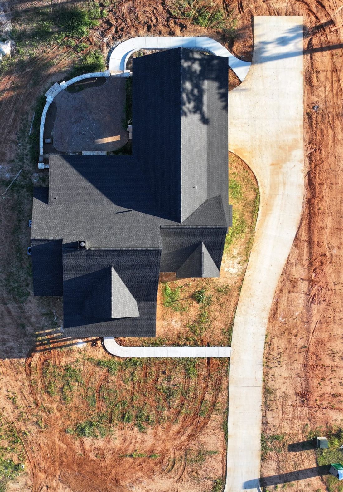
Straight-down drone photo of a new house, driveway, walks and brick patio
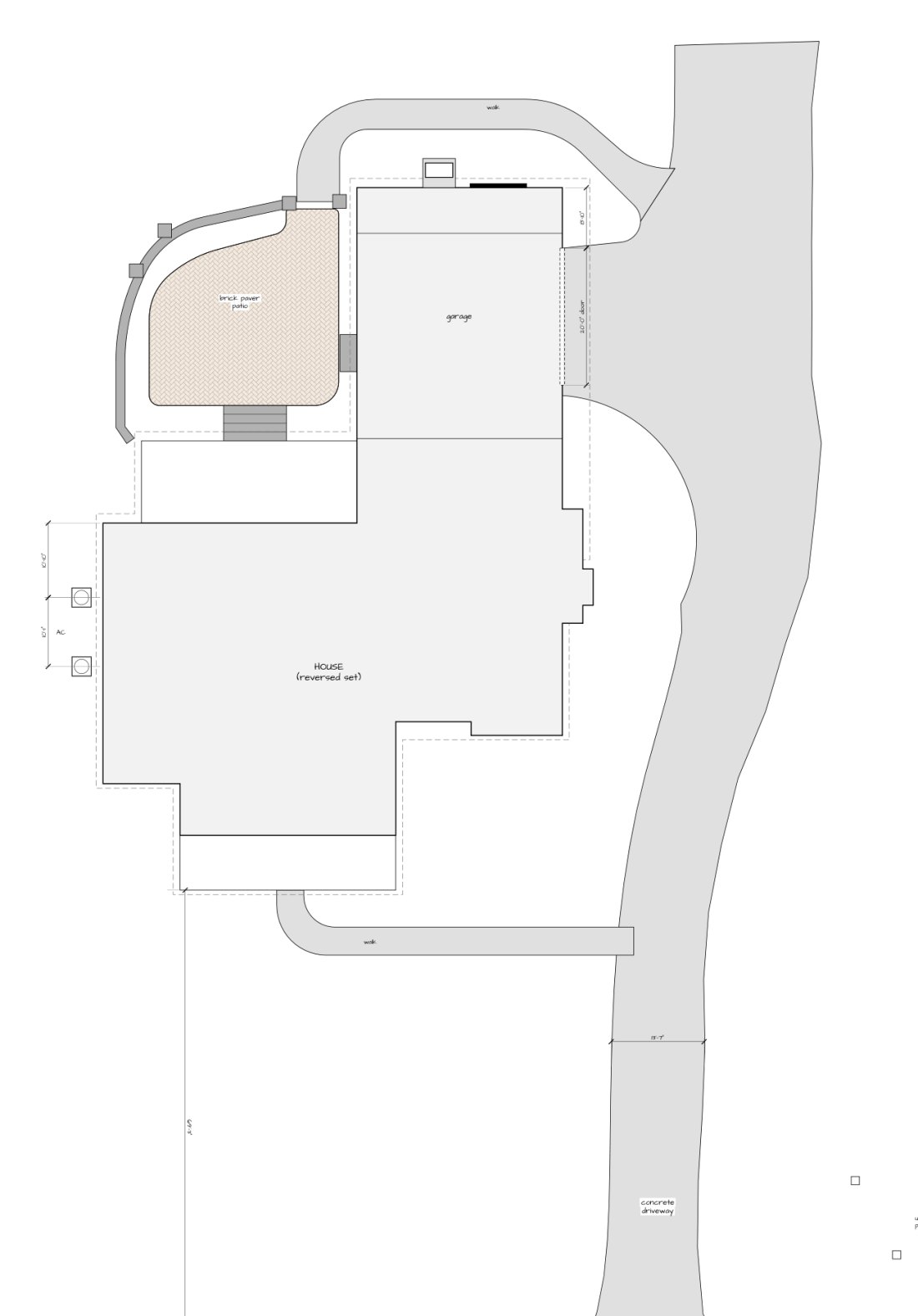
To-scale as-built site plan drawn from the drone photos
PhotoSite plan
Drag to compare · ↻ to turn
PilotFAA Part 107 certified
Site plansWithin a few inches of the house
Service areaPolk County, FL
PricingFixed quote before we fly
A-100
What we fly

Four things a drone does well.

Each one ends in something you can use: a drawing, a dated photo set or a report, not just a folder of pictures.

As-built site plans

What was actually built, drawn to scale.

  • House outline, driveway, walks, patio, pads and steps
  • Generator, meters and AC units placed and dimensioned
  • Corrections to the plan set where the build differs
  • PDF drawing plus a Google Earth (KMZ) overlay

Construction progress

The same views, every visit, dated.

  • Straight-down overhead of the whole site
  • Angled photos from set positions each time
  • Short 4K video walk-around
  • Shared folder for owner, builder or lender

Roof & tower inspection

Close-up photos without a ladder or a climb.

  • 3x and 7x zoom cameras for detail from a safe distance
  • Roofs, flashing, gutters, antennas and mounts
  • Photo report with each finding located
  • Visual only: see the limits below

Property aerials

Listing and marketing photos and video.

  • High-resolution stills from the best angles
  • 4K video for listings and social
  • Lot lines of sight, roads and surroundings
  • Edited and delivered ready to post
A-200
A real job

One flight, one drawing.

A new house in Georgia, flown once. The plan set was the builder's; the drawing is what was actually poured, laid and set. Slide the image at the top of the page to compare.

What the flight found

  • The garage has one 20-foot door where the plans show two, and it sits 3 feet off center. The plan set was corrected on four sheets.
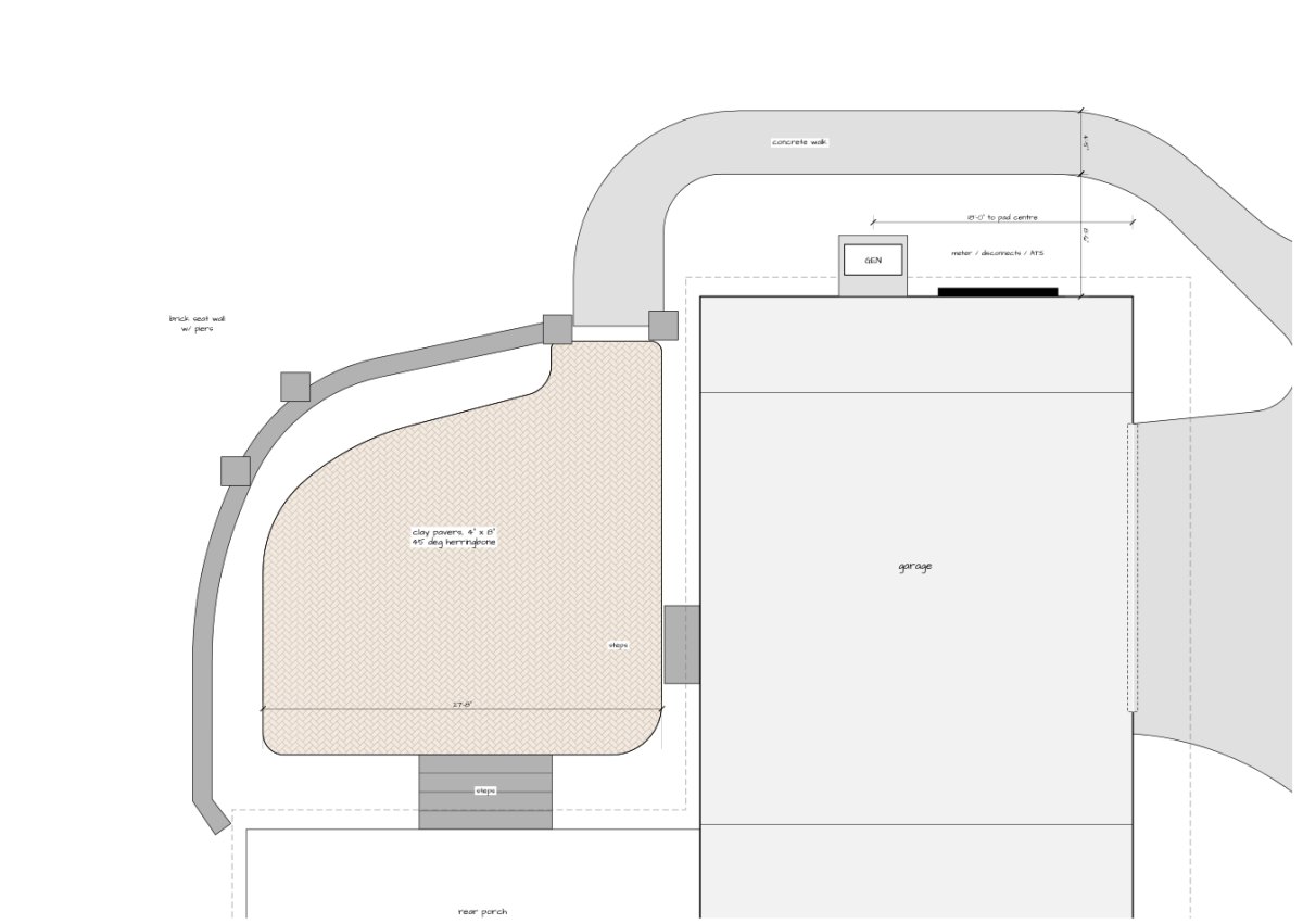
  • The patio's planting bed, seat wall, piers and steps drawn to scale from the photos.
  • Driveway, both walks and the island curb traced and dimensioned, including a 20'-11" radius curb.
  • Generator pad, meter bank and both condensers placed and measured from the walls.
  • No tape measure on site. The drawing is fitted to the builder's roof plan and checked between photos taken at three heights.

Address, street and neighboring lots removed for the owner's privacy. Photo metadata stripped.

Enlarged as-built plan of a brick paver patio, seat wall, walk, generator pad and garage

Enlarged plan from the same flight: herringbone brick patio, seat wall with piers, 4-foot walk, generator pad and meter bank.

A-300
Straight answers

What it is, and what it is not.

We would rather tell you now than after the flight.

What you get

  • Drawings accurate to a few inches relative to the house
  • Photos and video from a Hasselblad 4/3 camera with 3x and 7x zoom
  • Airspace checked and authorization obtained where required
  • Flights with the owner's consent, neighbors kept out of frame

What we do not offer

  • Boundary or topographic surveys: those need a licensed land surveyor
  • Elevations, grades or spot heights
  • Thermal or infrared imaging
  • Structural or engineering assessments of roofs or towers
FAQ
Before you call

Common questions.

Is an as-built site plan a survey?

No. It is a to-scale reference drawing of what was built, good for closeout, landscaping, pool or fence planning, insurance and your own records. It does not locate property lines. If you need a boundary or topographic survey, you need a licensed land surveyor, and we are happy to point you to one.

How accurate is it?

Driveways, walks, patios and equipment are placed within a few inches of the house. The house outline comes from your plan set, fitted to the photos. We note on every drawing what was measured and how, so nobody mistakes it for more than it is.

Can you fly anywhere?

Most of Polk County, yes. Near airports we get FAA authorization first, and a few places are off limits. We check your address before we quote and tell you straight if it cannot be flown.

What about my neighbors' privacy?

We fly with the property owner's permission, keep the flight over your lot as much as we can, and crop or remove neighboring property from what we deliver.

How much does it cost?

It depends on the size of the site and what you need at the end. Tell us about it and you get a fixed price before anyone flies.
CONTACT
Get in touch

Tell us about the site.

An address or a pin on a map, what you need the flight for, and when. We check the airspace and call you back.

(877) 280-7478Straight to the people who do the work
EmailSend the form and a real person replies
MORnet Communications, LLC728 N Scenic Highway, Lake Wales, FL 33853
Service areaCentral Florida and South Georgia

Call Get a free quote